BHUBANESWAR, ODISHA +91 9437 033 041 / +91 9438 244 627 dcsbbsr@gmail.com / info@dcspl.co.in

Photogrammetry, as its name implies, is a 3-dimensional coordinate measuring technique that uses photographs as the fundamental medium for metrology (or measurement). The fundamental principle used by Photogrammetry is triangulation or more specifically called Aerial Triangulation. By taking photographs from at least two different locations, so-called “lines of sight” can be developed from each camera to points on the object. These lines of sight (sometimes called rays owing to their optical nature) are mathematically intersected to produce the 3-dimensional coordinates of the points of interest.

Branches of Photogrammetry

In this technology world , There are two broad based branches of Photogrammetry .

Metric Photogrammetry

It deals with the precise measurements and computations on photographs regarding the size, shape, and position of photographic features and/or obtaining other information such as relative locations (coordinates) of features, areas, volumes, These photographs are taken using a metric camera and  is mostly used in the engineering fields e.g. surveying etc .

Interpretive Photogrammetry

It deals with recognition and identification of the photographic features on a photograph such as shape, size, shadow, pattern etc to add value and intelligence to information seen on the photograph (annotation).

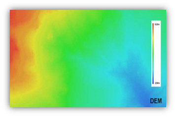
A digital elevation model (DEM) is a 3D CG representation of a terrain’s surface – commonly of a planet (e.g. Earth), moon, or asteroid – created from a terrain’s elevation data. A “global DEM” refers to a Discrete Global Grid.

Types

A DEM can be represented as a raster (a grid of squares, also known as a heightmap when representing elevation) or as a vector-based triangular irregular network (TIN). The TIN DEM dataset is also referred to as a primary (measured) DEM, whereas the Raster DEM is referred to as a secondary (computed) DEM. The DEM could be acquired through techniques such as photogrammetry, lidar, IfSAR, land surveying, etc. (Li et al. 2005). DEMs are commonly built using data collected using remote sensing techniques, but they may also be built from land surveying.

Uses
Common uses of DEMs include:
  • Extracting terrain parameters for geomorphology
  • Modeling water flow for hydrology or mass movement (for example avalanches and landslides)
  • Modeling soils wetness with Cartographic Depth to Water Indexes (DTW-index) [14]
  • Creation of relief maps
  • Rendering of 3D visualizations.
  • 3D flight planning and TERCOM
  • Creation of physical models (including raised relief maps)
  • Rectification of aerial photography or satellite imagery
  • Reduction (terrain correction) of gravity measurements (gravimetry, physical geodesy)
  • Terrain analysis in geomorphology and physical geography
  • Geographic information systems (GIS)
  • Engineering and infrastructure design
  • Satellite navigation (for example GPS and GLONASS)
  • Line-of-sight analysis
  • Base mapping
  • Flight simulation
  • Precision farming and forestry
  • Surface analysis
  • Intelligent transportation systems (ITS)
  • Auto safety / advanced driver-assistance systems (ADAS)
  • Archaeology

Imagery has an amazing amount of information, but raw aerial or satellite imagery cannot be used in a GIS until it has been processed such that all pixels are in an accurate (x,y) position on the ground. Photogrammetry being a discipline, developed over many decades, for processing imagery to generate accurately georeferenced images, referred to as orthorectified images (or sometimes simply orthoimages). Orthorectified images have been processed to apply corrections for optical distortions from the sensor system, and apparent changes in the position of ground objects caused by the perspective of the sensor view angle and ground terrain.

Orthorectification is the process of removing the effects of image perspective (tilt) and relief (terrain) effects for the purpose of creating a planimetrically correct image. The resultant orthorectified image has a constant scale wherein features are represented in their ‘true’ positions. This allows for the accurate direct measurement of distances, angles, and areas (i.e. mensuration). Orthorectified images are commonly used as in visualization tools such as Google Earth, OSSIM Planet, ArcMap, WMS, etc.